

Explainable Machine Vision Techniques for Geo-spatial Land Use Classification
Applied Explainable machine vision techniques for geospatial land use classification using CNNs, ResNets, GoogleNets, and Vision Transformers. Achieved 98% accuracy and applied SHAP values and class activation maps for model interpretation and real-time geospatial monitoring.
Explainable Machine Vision Techniques for Geo-spatial Land Use Classification abstract;
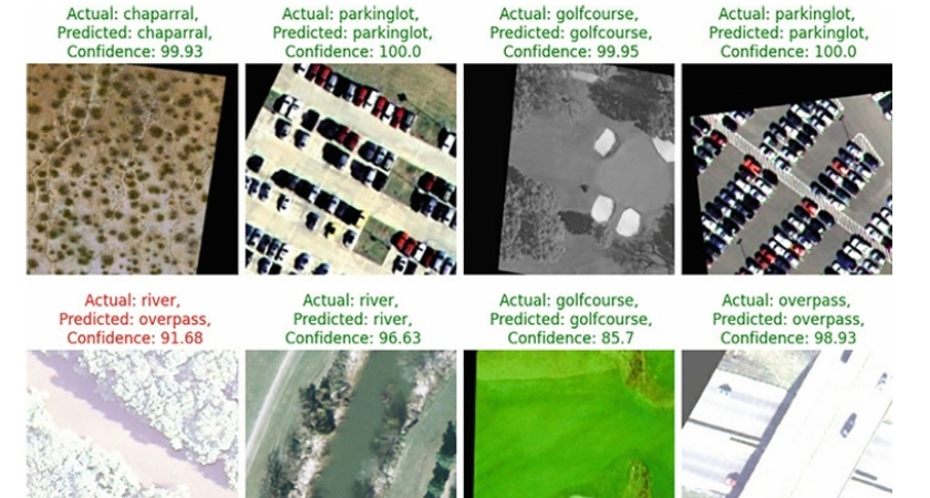
Land use classification plays a crucial role in policy development, urban and rural planning, land valuation, energy planning, and forest cover monitoring, among various other applications. The chapter uses Convolutional Neural Networks, Residual Networks, Visual Geometry, Vision Transformers and the GoogleNets for land use classification tasks. Precision was chosen as the primary evaluation metric, and the Vision Transformers emerged best for land use classification with the highest precision and recall. It attained a validation accuracy, F1 score, precision and recall of 98, 98, 98 and 98% respectively. Visual explainers of the models were derived based on model-agonistic shapely values, class activation maps with layer-wise relevance backward propagation to establish the most and least relevant feature class determinants used informing the classification decisions. With deep transfer learning, we improved the model peformance before deplying the best model in on various platforms for real-time analysis. This work provides benchmarks for building more realtime responsible software systems with geo-intelligence for geospatial predictive monitoring.
Case Information
- Client : Academic Project
- Company : Makerere University – CoCIS
- Project Start Date : 01 Mar, 2024
- Project End Date : 23 May, 2025
- Comment : Applied explainable AI for accurate geo-spatial land use classification.
- Demo Link : Click Here
Explainable Machine Vision Techniques for Geo-spatial Land Use Classification